Freezing polar blast sparks weather warnings in five states and territories
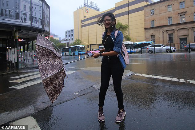
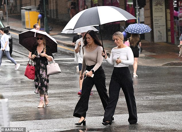
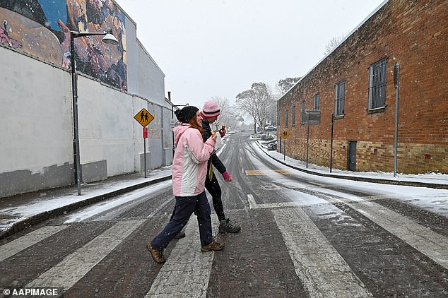
Millions of Aussies in five states will be blasted with rain, damaging winds, thunderstorms and snow as a cold front wreaks havoc across the country.
A wet weather system tracking across New South Wales and Victoria will bring powerful wind gusts and rain with warnings issued across multiple states.
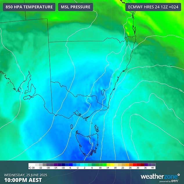
The poor weather is fuelled by a complex low-pressure system which moved from the west coast to the southeastern states earlier this week.
That system will also be the driving force behind a 'large pool of cold polar air moving northwards from the Southern Ocean' across the southeast, Weatherzone meteorologist Ben Domensino warned.
'This procession of cold fronts, along with the associated low pressure system, will cause damaging winds, showers and wintry temperatures across parts of SA, Tasmania , Victoria, the ACT and NSW on Wednesday,' he said.
'Severe weather warnings have been issued for damaging wind gusts in parts of all five states and territories.'
Major cities included in that severe weather warning include Sydney, Newcastle and Wollongong, with winds up to 100km/h possible.
Conditions are even worse in alpine regions, which could see gusts up to 120km/h and possible blizzard conditions.
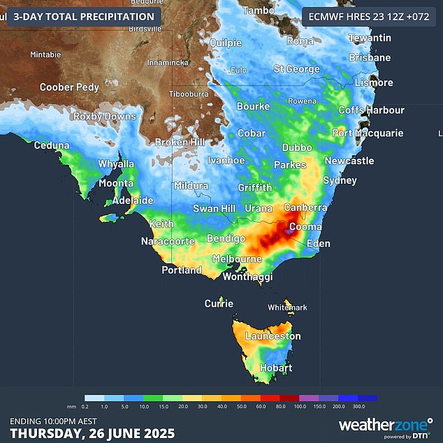
The heavy rain sweeping across the southeast is expected to fall as snow down to 500metres on Wednesday and 900metres on Thursday.
'This should deliver about 20cm to 30cm of fresh snow to the mainland ski resorts, making up for the snow that was melted by Monday night's pre-frontal rain,' Mr Domensino said.
The worst of the low pressure system is forecast to be driven offshore by a high pressure system from Thursday.
That high pressure system originated in the Great Australian Bight and is set to bring calm conditions to much of central and western parts of Australia from Wednesday.
Sydney
Thursday : Partly cloudy. Medium chance of showers along the coastal fringe, slight chance elsewhere. The chance of morning frost in the outer west. Winds southwesterly 15 to 20 km/h tending southerly 15 to 25 km/h during the day then becoming light during the evening. Min 8. Max 17.
Friday : Partly cloudy. The chance of morning fog in the west. Medium chance of showers. Light winds. Min 10. Max 18.
Saturday : Partly cloudy. Medium chance of showers. Light winds. Min 9. Max 19.
Melbourne
Thursday : Cloudy. Medium chance of showers, most likely in the early morning. Winds west to southwesterly 15 to 20 km/h tending south to southwesterly in the early afternoon then becoming light in the evening. Min 7. Max 13.
Friday : Cloudy. The chance of morning fog. Slight chance of a shower, most likely during the morning. Light winds. Min 6. Max 14.
Saturday : Partly cloudy. Areas of morning frost about the nearby hills. The chance of morning fog. Light winds. Min 5. Max 15.
Brisbane
Thursday : Sunny. Winds westerly 15 to 20 km/h becoming light before dawn. Min 11. Max 20.
Friday : Partly cloudy. Light winds. Min 10. Max 21.
Saturday : Partly cloudy. Medium chance of showers, most likely in the morning and afternoon. Light winds. Min 13. Max 21.
Perth
Thursday : Sunny. The chance of morning frost in the southeast. Light winds. Min 5. Max 20.
Friday : Sunny. Light winds. Min 7. Max 21.
Saturday : Mostly sunny. Winds easterly 15 to 20 km/h tending northeasterly during the day then becoming light during the afternoon. Min 7. Max 21.
Adelaide
Thursday : Cloudy. The chance of morning fog. Slight chance of a shower. Light winds. Min 7. Max 15.
Friday : Cloudy. Light winds. Min 7. Max 16.
Saturday : Partly cloudy. The chance of morning frost about the northern suburbs. Light winds. Min 5. Max 15.
Hobart
Thursday : Partly cloudy. Slight chance of a shower. Winds west to northwesterly 15 to 20 km/h becoming light in the late afternoon. Min 4. Max 13.
Friday : Partly cloudy. Slight chance of a shower. Light winds becoming northwesterly 15 to 20 km/h during the day. Min 6. Max 14.
Saturday : Partly cloudy. Slight chance of a shower, most likely in the afternoon and evening. Winds northwesterly 15 to 25 km/h becoming light during the evening. Min 6. Max 15.
Canberra
Thursday : Partly cloudy. Areas of morning frost. Light winds. Min -5. Max 10.
Friday : Partly cloudy. Areas of frost and the chance of fog in the morning. Light winds. Min -3. Max 13.
Saturday : Areas of frost and the chance of fog in the morning. Mostly sunny afternoon. Light winds. Min -3. Max 14.
Darwin
Thursday : Sunny. Light winds becoming southeasterly 20 to 30 km/h in the morning then becoming light in the evening. Min 22. Max 32.
Friday : Mostly sunny. Light winds becoming southeasterly 20 to 30 km/h during the morning then becoming light during the afternoon. Min 21. Max 31.
Saturday : Partly cloudy. Light winds becoming southeasterly 20 to 30 km/h during the morning then becoming light during the evening. Min 22. Max 31.
Read more
Posting Komentar untuk "Freezing polar blast sparks weather warnings in five states and territories"
Posting Komentar